We met at 9:30 at Bays Mountain Park where we set off on our first grand adventure, the longest hike thus far this year 8.5 miles. Our goal, hike from Bays Mountain Park through to Laurel Run Park in Church Hill, have fun, take

pictures and new discoveries. On the hike was myself, my best friend April and my niece Kayla. This was Kayla's first BIG hike and we would soon see her take it like a pro.
We started off across the dam (at BMP) where old and young fishermen alike threw out their lines in hopes of an evening fish fry. Out of the four, only one had caught a single bluegill. Maybe Long John's was in order.

We took Lake Road along the ecology pond where we saw beautiful blooming mountain azaleas and checked the radar which was really looking threatening. Upon reaching Ledbetter Gap, we decided to adorn ourselves in the new plastic smell of ponchos. Better to stay dry than start off soaked. Cresting the top of Lake Road at the by-junctions of Cherry Knobs, we could see the rain coming toward us on the next knob. Still no rain as we reached Feagins Gap, but we are now soaked through because of the condensation from sweating in the ponchos. It wasn't until we were near the Cabin at the Primitive Campground that it began a very

light shower which was fine because we sat on the front porch and ate lunch, talked about what we may run into, what the guys would be going through at that time, and checking in so Dad would know just where we were at that moment.
After a full stomach and an equal amount of laughs, we set off for Back Hollow Road where the word
Marsh was an understatement. I renamed this part of the trail, the "stinky-sewer-knee-deep-boot-sucking-funky-nasty-bio-

gunk trail". We made it but next time will opt for bushwhacking to get around that mess. But Back Hollow Road was not through with us yet. After crawling out of the bio gunk, we were smooth sailing. That is until we come upon a barbed-wire fence. Hmm... that's not on the map. We each look at the other as if to say... alright, did we take a wrong turn? We stood on that fence, puzzled, because I knew that some of the trails did border private property but could not figure out where we had gone wrong. By my map and compass readings I felt we were right... but that fence was telling us otherwise. After several minutes went by I decided to go on ahead and see what was further through this wet pastureland. I came upon an old barn and busted up old house... just like the map said. Then I spotted a fella working on the fence. After consulting him, he agreed we were on the trail. Turning around and heading back to April and Kayla, I spotted our familiar white blaze. Soon they joined me and another dead end. Still in eyesight of the farmer, who problaby thought we were nuts and laughing under his breath, we searched and searched and searched for the next white blaze to guide us. Pretty Ridge Trail should be nearby but we couldn't find its entrance anywhere. Then

Kayla bent down to tie her shoes and when she came up, let out a "I found it!" Now, take a look at this picture and tell me where it is. Good grief!
So we headed up an incline of 400 feet in .4 of a mile, but at halfway we came to yet another confusing junction. Trees were down everywhere, blueberry bushes thick with blackberry briar's and the brush... this was a job for the Boys Scouts if I ever saw one! The infamous double blaze. Thinking to myself, double blaze was a cautious area, confusing area or trail split. Eenie, meanie, miney, moe... After 30 minutes of calculating time, distance and compass, we agreed that we must not be at the Pretty Ridge junction yet. We continued up the incline and sighed a breath of relief when we discovered we once again trusted our instincts and made it.
Cruising along Pretty Ridge Road was simply beautiful, rightfully named. Its trail was smooth through beautiful large growth of trees, with deep views of the forest floor. Pictures did not do it justice. I have decided that Pretty Ridge is indeed my favorite trail on this mountain. And it has phone signals! Whoohoo!
So we are moving pretty good, when out of the blue, we spot a strange little flower. In my many years of hiking, I had never seen one. I would later discover it was a "Lady Slipper". So sweet!
We reach Kiner Hollow Trail where we run into the first people since the Dam. A husband and wife, the hubby was training for his week long hike in May on the A.T. We chatted for a few minutes, discovering in his pack was 25 pounds, myself carrying about 12 pounds with ease. Not long after, we reached another couple who after a brief chat over where on the map they were, where they thought they would go, and realistically realizing they would not make it to that point by dark, much less back to the park, we decided we just saved a marriage, for they turned around and headed back to the park with dogs in tow.
Then there was the sound... a sound that stops you in your tracks, even though your heart begins to race, your ears suddenly tune into every sound surrounding you within half a mile. A growl, a low deep long growl from

behind the old Roller Simpson place, a broken down home located along the trail. We all three froze mid-step, arms frozen in mid-sway, Ron Howard could not have directed that stop better. We stood stock still, another growl followed equally by the click, clank, click, clank sound of footsteps and another eerie growl. Eyes now as big as saucers, we looked at each other to see who knew. No answer, then as the sound got louder, a B U Z Z A R D perches at the top of the house and looks down on us! A FRIGGIN BUZZARD! All visions of bear suddenly shot out the window, thankfully, and we forced all our food back down, lowered our heart rates somewhat, and investigated the house. I'm quite certain the buzzard must have had a nest nearby.
We finished up Kiner Hollow and made it to Laurel Run Trail. Another beautiful scenic forest embedded with great pines, hemlocks and Rhododendrons. Springs pushed through many areas throughout this trail and ferns nearly hip high adorned the forest floor as well as beautiful Spring flowers. This is also where the waterfalls began. One in particular, the highest of them all, I was determined to reach the bottom, something I wasn't able to do last year. Problem was, the "path" down to the bottom was a wet, muddy drop off of about twenty feet. Footing was next to impossible. I knew we could get down... eventually, gracefully or not. The question would be "How the heck do we get back up!?" We'd figure that out later. Leaving our packs at the top, we slid, scooted, and crawled down to the bottom where the falls were stunning. After taking many photos, we were ready to head on up. Kayla took to it like a seasoned mountain goat, standing at the top in just a few minutes. April and I were next, carefully checking our footholds, digging roots to create handholds, we scaled up the mucky wall AND MADE IT TO THE TOP! The sense of accomplishment was unbelievable! I tried and tried to take a photo to show just how steep the incline was, but no matter, unless one of us was to climb back down and climb back up, the photos appear to be level. UGH! We were so excited... and still are because we knew that many people who knew us would have said there was no way we could get down much less back up AND WE DID IT!
We continued down the trail to see more waterfalls where we were surprised by our ride... Mike and Hunter, sneaking up on us as we cooled our feet in the icy cold mountain water. It was a pleasant surprise as we told of how we had just accomplished something amazing.
We started out with a goal yesterday and I am sure we succeeded 100%. We dug deep (literally), discovered something we always felt, that as a team we can do anything.
Thank you April and Kayla for making that day so special! Stinky hugs and more hiking!
Sandra



 who had no interest in having its photo taken and quickly slithered off for the protection of the log cabin nearby...
  who had no interest in having its photo taken and quickly slithered off for the protection of the log cabin nearby...
  The day before, moderately heavy rains swept through the area giving us a chance to enjoy the waterfalls in full flow.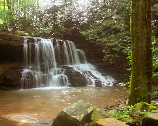
 The day before, moderately heavy rains swept through the area giving us a chance to enjoy the waterfalls in full flow.
 This is a beautiful area
 This is a beautiful area


